Comparing drone photogrammetry software 2024


With photogrammetry software, you can turn photos into maps and 3D models. Get to know a selection of the best programs on the market now!

Comparing drone photogrammetry software 2021
Aerial photographs not only look spectacular, they are also ideal for precise measurements of objects such as buildings, construction sites and landscapes. Photogrammetry software makes it possible to convert photos into 2D and 3D objects.
What is photogrammetry?
Photogrammetry is about extracting 2D and 3D information from photos that is suitable for precise measurements. Photogrammetry software can be used to create digital versions of objects, such as landscapes and buildings. Surveyors, architects and craftsmen such as roofers, among others, use the method. To do this, drone pilots take the images from the air and transfer them to photogrammetry software. The application then generates a drawing, map, or 3D model. The leading software solutions automatically create high-resolution 3D models from the photos.
How does photogrammetry work?
The method uses parallax between several 2D images, which are taken from different angles of view, and generates 3D images from this using complex algorithms. The shape, depth and volume of objects are retained. The more aerial photographs are available, the more precise the result of the photogrammetry software is.
What types of photogrammetry are there?

There are two types of photogrammetry: aerial and terrestrial photogrammetry. In aerial photogrammetry, the camera is attached to an airplane, helicopter, or drone and captures numerous overlapping images. In land-based photogrammetry, the photos are usually taken by hand or with a tripod.
The best photogrammetry software 2021
There are numerous programs available on the market for different requirements. Below, we'll introduce you to the functions and features of the best software solutions for photogrammetry.
Drone Deploy

The cloud-based software Drone Deploy creates 2D and 3D maps from aerial photographs. Two apps are available: one for controlling the drone and one for 3D generation. Using the Aerieal 3D mapping software, the drone pilot first plans the flight route, which is then automatically flown by the drone.
benefits
- Users can create measurements themselves
- There is a free drone flight app for iOS and Android for selected drone models
drawbacks
- Provider from the USA - only available in English
- Get started from $329 per month
- No support in Germany
- Measurements do not comply with German regulations, e.g. not VOB compliant
- Manual measurements in the software are time-consuming and can lead to large deviations
- Automated evaluations are highly susceptible to errors
Customer Testimonials
“Quite expensive software for pilots, and also for “analyst” users who can only view the data. We usually just export or send links to our teams.”
Pix4D

The professional photogrammetry software Pix4D not only creates elevation maps, point clouds and 3D networks, but also helps with image capture. The Pix4Dcapture mobile photogrammetry app for Android and iOS transforms a standard drone into a survey drone. The software requires enough overlapping images to process and controls the flight path to ensure optimal overlap.
benefits
- Users can create measurements themselves.
- There is the free Pix4Dcapture drone app for selected drone models, and the software can also be used without Pix4D.
drawbacks
- Pix4Dmapper for the desktop PC costs 4,000€ per year - without drone & without survey reports.
- Customer support is often unavailable.
- Users do not receive a measurement report, the measurements cannot be generated automatically.
- It takes a lot of time to create the measurements yourself; the 3D measurement points are often difficult to correctly determine.
Propeller Aero

The cloud-based photogrammetry software Propeller Aero enables the visualization and analysis of construction sites. The focus is on the analysis of civil engineering projects. Experts worldwide use the applications in mining, civil engineering and waste management, among others, to collect precise survey data about their plants and construction sites. The data answers questions about progress, work quality, productivity, and safety.
benefits
- Intuitive to use
- RTK drone accuracy
- Easy georeferencing thanks to smart GCP's (Aeropoints - costs: 7,200 USD)
- Sales partner in Germany
drawbacks
- Pure civil engineering solution (earthworks, extraction and disposal industry)
- Prices only on request
- Lack of recognition of the data obtained for public sector projects
User Testimonials
“The software doesn't always tell you the truth at first glance. You really need to be aware of how the calculations are done, or you could end up accidentally reporting incorrect results. I also find that loading 3D models and other drawings into Propeller can be frustrating, although it seems to be getting easier.”
Propeller | 3D Drone Mapping & Analytics
DJI Terra

With DJI Terra, drone pilots capture, analyze and visualize the environment. With the mapping software, users transform real objects into digital assets. 3D flight visualization is used for more complex tasks and for detailed images. A 3D point cloud can be quickly rendered and displayed, and users measure areas, volumes, distances and coordinates with DJI Terra.
Tutorial video: https://www.youtube.com/watch?v=AZH-hR_GM0c
benefits
- A drone flight app is included, although individual functions are chargeable.
- Collected data can be further processed quickly.
drawbacks
- The photogrammetry software only works with selected DJI drones such as the Mavic 3 Enterprise RTK, but not with the DJI Mavic 3.
- Depending on the version, costs of 1,000 to 3,000€ arise.
- Most software and support are only available in English.
- The workflow is complex, with a PC and drone in use on site.
Agisoft Metashape

Agisoft Matashape (formerly Agisoft Photoscan) generates 3D data from digital images that can be used in GIS applications. The software processes most of the photos automatically into precise 2D and 3D models, which can include point clouds, georeferenced orthophotos or textured polygonal models. With Agisoft Metashape, drone images can be evaluated, objects digitally displayed and measured.
The current version of Agisoft Metashape 1.7 automatically recognizes power lines on images, creates better depth maps using new algorithms and can reconstruct thin structures using photogrammetry. The Agisoft Cloud saves the investment in hardware for the processing process; projects can be conveniently stored in the cloud. There is a standard edition and a professional edition, and the tool can be tried out for 30 days as part of a free license.
Benefits of Agisoft Metashape
- Edit and classify point clouds
- Suitable for GIS applications and building documentation
- Workflows customizable with Phyton scripts
- 3D and 4D modeling
- Data processing in the cloud is possible
Disadvantages of Agisoft Metashape
- The available RAM limits the maximum possible project size. 32GB RAM is recommended for a basic configuration and up to 128GB RAM for an advanced configuration.
- According to Agisoft, a processor with at least six cores and more than 3 GHz should be used to calculate the complex algorithms.
Virtuosity ContextCapture

The photogrammetry software Virtuosity ContextCapture is aimed at the requirements of construction and surveyors. They create precise 3D networks using the application and the Reality Modeling Worksuite.
benefits
- Drone pilots can create measurements on their own.
- The quality of the 3D models is very high.
- 3D models can be generated from aerial photographs from drones and also from ground images from smartphones.
drawbacks
- Creating the measurements takes a lot of time, and there are often problems with correctly defining the 3D measurement points.
- The user interface of the photogrammetry software is not very user-friendly.
- The software costs 3,000 to 5,000€ per year - without drone & without survey reports.
- Software and customer support are only available in English.
- Users need previous knowledge in the area of photogrammetry and measurement.
- A powerful PC is required.
- Measurements cannot be automated.
- No survey report is created.
Tutorial video: https://www.youtube.com/watch?v=cpJltTkXP1I&list=PLfz1tXwSP3Xsx1ciE439y-S6xYgLDhVv4&index=10
Recap Pro from Autodesk

In 2009, Autodesk released the free photogrammetry software 123D Catch, which can be used to transform photos into 3D models. The software solution is no longer being developed, but users can now use Autodesk Recap Pro Create accurate 2D and 3D models based on imported photos, aerial photography, and laser scans. The scan software supports users with a point cloud or a network during BIM processes (Building Information Modeling); the data can be combined with other CAD programs be further processed.
benefits
- Drone pilots can create measurements on their own.
- The quality of the 3D models is very high.
- 3D models can be generated from aerial photographs from drones and also from ground images from smartphones.
- The subscription costs less than 400€ per year.
drawbacks
- A powerful PC with an OpenGL 3.3-capable graphics card and at least 1 GB of graphics memory is recommended.
- The generation of measurements cannot be automated.
- Very complex user interface that requires many years of experience working with CAD software
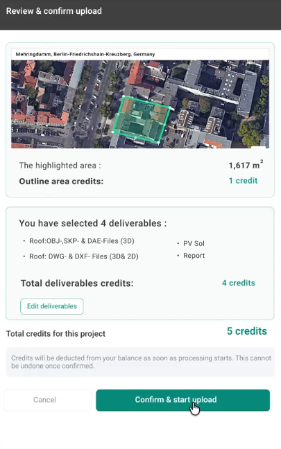
Airteam Fusion Platform

Airteam specializes in the cost-effective creation of roof and building dimensions. The measurement is carried out using drones, 3D modelling and computer vision technology. With the Airteam Fusion Platform, users save up to 90 percent of time and costs compared to measuring by hand or laser. Customers can use the Airteam Fusion Platform to view their data stored in the cloud at any time and from anywhere and share it with the team or with external partners. Thanks to the Airteam API, users can directly access the data and process it as quickly as possible.
benefits
- The measurement report is individually adapted to customer needs.
- Artificial intelligence (AI) automatically recognizes surfaces and edges.
- Users can easily create the 3D CAD models with 3D design software Sketch Up or PVsol Premium further process for photovoltaic installations.
- Customers either carry out drone flights themselves or book an experienced pilot from Airteam.
- Software, customer support and training are in German.
- Drone training for self-piloted drone flights is available online and on site.
drawbacks
- The cost per measurement is at least 100€.
- Data evaluation by Airteam takes around 48 hours (up to 1,000 m²) and up to 5 days (over 10,000 m²).
Summary & outlook on photogrammetry software
The photogrammetry software solutions differ greatly from one another in terms of the accuracy of the 3D models, user-friendliness and complexity. The Airteam Fusion Platform is one of the best drone photogrammetry software solutions and impresses with precise measurement data and detailed survey report. The photogrammetry software impresses with its simple operation, the individual adjustment of the results to your own needs and the options for further processing of the collected data.